


Shoreline Preservation By-Law 4169-Complaint Form
If you have observed shoreline work that you wish to report to the county please use the linked form below.
Shoreline Complaint Reporting Form
Shoreline Preservation By-Law 4169
The County of Haliburton is fortunate to have many lakes and rivers that contribute environmentally, economically, and socially to the County. These lakes are home to a wide range of aquatic species, plants, and animals. They support a thriving tourism industry and provide a home for many residents. Additionally, the lakes offer countless recreational opportunities, including swimming, boating, and fishing.
The health of these lakes and rivers are essential for both residents and businesses. The Shoreline Preservation By-law seeks to strike a balance between the rights of shoreline property owners to use and enjoy their property, with the preservation of the natural environment, lake health and natural aesthetics.
The Shoreline Preservation By-law is designed to regulate situations where a property owner (or their representative) plans to make significant changes to the grade or topography of their property that could increase the flow of surface water onto neighboring lands or bodies of water.
It also applies when there is a proposal for the substantial removal of trees and/or vegetation. In these cases, property owners must apply for and obtain permit approval before proceeding with such major projects or activities within the shoreline buffer area.
The Shoreline Preservation By-law 4169 can be found here: Shoreline Preservation Bylaw
If you require a shoreline permit application, it can be found here: Application
Area of Application of the Shoreline Bylaw
The Shoreline Preservation By-law applies to lands 20 metres inland from the high-water mark of all lakes, rivers, streams and ponds in the lower-tier municipalities of Algonquin Highlands, Highlands East and Minden Hills. The Shoreline Bylaw also applies to significant wetlands. (These can be found at the County's GIS Webmap: County GIS )
Municipal Shore Road Allowances
Some waterfront properties within the County are separated from the water by a strip of land known as a “Shore Road Allowance” (SRA). SRAs are typically 20 metres (66 feet) in depth from the water's edge and were originally established on crown land to facilitate activities such as logging. Portions of shore road allowances are sometimes 'flooded' with the high water mark being within them.
Unless the SRA has been purchased by the abutting waterfront owner they remain under the ownership of the local Municipality. Under By-law 4169 lands owned by the Local Municipalities are considered prohibited areas, where no shoreline activity may occur including vegetation removal or alterations of grade. Only the removal of dangerous trees is permitted in a prohibited area.
If you are looking to undertake a project on your shoreline, but do not own it, you must first contact your local municipality about purchasing the shore road allowance. Property owners are also encouraged to speak with County Staff when seeking to purchase the SRA for the purpose of shoreline work.
Useful Information
| Activities Exempt From Requiring a Permit |
|
Section 5 of By-law 4169 outlines exempted activities which do not require a shoreline permit; most common exemptions are:
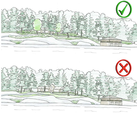
The image below illustrates shoreline area with the applicable 20-metre setback. It also provides an example of an allowable access area, where up to 25% of shoreline vegetation removal may occur. The County encourages property owners to minimize vegetation removal; however, up to 25% may be removed under an exemption.
If you're a property owner planning shoreline work, you can fill out the short self-assessment form below to help determine if you need a shoreline permit from the County By-Law 4169, Shoreline Preservation Project Self-Screening Form |
| Shoreline Permits |
|
Shoreline permit applications are required for larger projects which do not meet the exemption criteria under section 5 of By-law 4169 described above.
If you are seeking to do shoreline work on your property and have questions about permitting, please contact the Shoreline Permit Administrator/Bylaw Compliance Officer here: amcmaster@haliburtoncounty.ca |
|
Shoreline Best Practices |
|
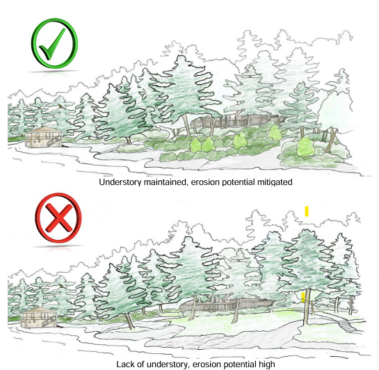
Vegetation and Natural Buffers
Erosion Control
Runoff and Pollution
Construction and Access
Septic Systems and Wastewater
Shoreline Land Use and Design
|

FAQ's
| What is a Shore Road Allowance, and do I own it? |
|
A shore road allowance is a strip of land 20 metres (66 feet) deep measured from the water's edge which separates waterfront properties from the lake. SRAs were originally established on crown land to facilitate activities such as logging, and many still exist. Unless title of the shore road allowance has been purchased by a property owner, it remains under the ownership of the local Township. Ownership information is typically found in the legal description of the deed of land for your property and can be confirmed by your solicitor. |
| When do I need a shoreline permit? |
|
By-law 4169 has an extensive list of exempted activities listed under Section 5. If a proposed activity does not meet the criteria for an exemption under section 5, then a permit application would be required. Please contact the Shoreline Bylaw Permit Administrator with questions about permitting. |
| How do I know where the high-water mark is? |
|
High water mark is the line where the land meets the water at a normal controlled level. High water mark can only be officially indicated by an Ontario Land Surveyor, or on a Plan of Survey. However, there are physical indicators that can give you a reasonable estimate of the location of the high-water mark. Water and pollen stains are typically left on hard surfaces such as rocks and logs, which can help indicate high water mark. Changes in the type or texture of soil, or erosion or undercutting of banks can also help indicate high water mark. |
| What is considered vegetation? |
|
Vegetation is considered the collection of plant species and the ground cover they provide, being all greenery including grasses, shrubs, weeds herbs and trees. |
| Can existing structures on the shoreline be rebuilt or maintained? |
|
Yes. Existing structures can remain be renovated or rebuilt with appropriate building permits from your local municipality. |
| What about existing shoreline structures, like rock walls, or drainage channels? |
|
Existing structures built on the shore with proper approvals can be appropriately maintained. Rocks/stones and materials may be replaced without a permit, so long as material type is not changing. Additions, extensions or major alterations to such structures require review by the County. |
| Once I apply for my Shoreline Permit, how long will it take to receive it from the County? |
|
The Director is required to issue a Shoreline Permit application within 30 days or provide reasoning if a permit is denied. |
| Does the by-law affect yard maintenance like weeding and minor landscaping? |
|
No. Property owners can continue to cut grass, remove weeds and maintain their waterfront yards. Property owners are encouraged to preserve and protect natural vegetation within the 20 metre shoreline area. Minor landscaping that does not change topography or water flow does not require a permit. Landscaping with native plants is better for the environment and easier to maintain. |
| What is a larger project that would require a permit? |
|
A larger project is one that:
Other examples include larger lot grading activities, storm water management projects or shoreline stabilization. Property owners must contact County Staff for such projects. |
| My shoreline is already sparsely vegetated, does this limit my ability to do work on my shoreline? |
|
Sparsely vegetated shorelines are treated the same as any other shoreline. However, with less vegetation the opportunity to remove vegetation is naturally lower. For example, owners are permitted to remove up to 25% of vegetation under exemption. Therefore, if you only have four trees on your shoreline, only one is permitted to be removed without applying for a permit. |
Feedback
You are also welcome to send any feedback you may have to the Director of Planning by emailing:
Elizabeth Purcell, Director of Planning, County of Haliburton: epurcell@haliburtoncounty.ca